Difference between revisions of "Tessere"
Jump to navigation
Jump to search
m |
|||
| Line 43: | Line 43: | ||
|- valign="top" | |- valign="top" | ||
| style="width: 25%;" | | | style="width: 25%;" | | ||
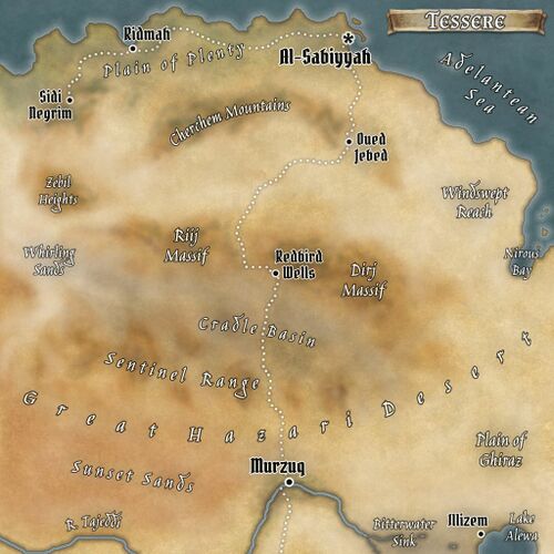
* [[]] | * [[Bitterwater Sink]] | ||
* [[]] | * [[Cherchem Mountains]] | ||
* [[]] | * [[Cradle Basin]] | ||
* [[Dirj Massif]] | |||
* [[Lake Alewa]] | |||
| style="width: 25%;" | | | style="width: 25%;" | | ||
* [[]] | * [[Nirous Bay]] | ||
* [[]] | * [[Plain of Ghiraz]] | ||
* [[]] | * [[Plain of Plenty]] | ||
* [[Riij Massif]] | |||
* [[Sentinel Range]] | |||
| style="width: 25%;" | | | style="width: 25%;" | | ||
* [[]] | * [[Sunset Sands]] | ||
* [[]] | * [[Whirling Sands]] | ||
* [[]] | * [[Windswept Reach]] | ||
* [[Zebil Heights]] | |||
</div> | </div> | ||
|} | |} | ||
Revision as of 01:37, 13 May 2023
| Allegiance | Sirdabi Caliphate |
| Capital | al-Sabiyyah |
| Demonym | Tessere |
| Official Language | Sirdabi |
| Official Religion | Azadi |
| Currency | fals/dirham/nour |
| Native Heritages | Tessouare, Sirdabi, Razmani, Bissenke |
The province of Tessere lies at the far western end of the Sirdabi Caliphate, the furthest of its north Idiri lands save for the neighboring Emirate of Koumbasi. To the north lies the Adelantean Sea, and to the south the equally vast expanse of the Great Hazari Desert, while its eastern border touches upoin rustic Ifru. Although remote from the Sirdabi capital, Tessere is a thriving land whose cultural and economic prosperity owe much to the Koumbasi gold trade and the province's key position as a middleman on the trans-Hazari and Adelantean trade routes.
