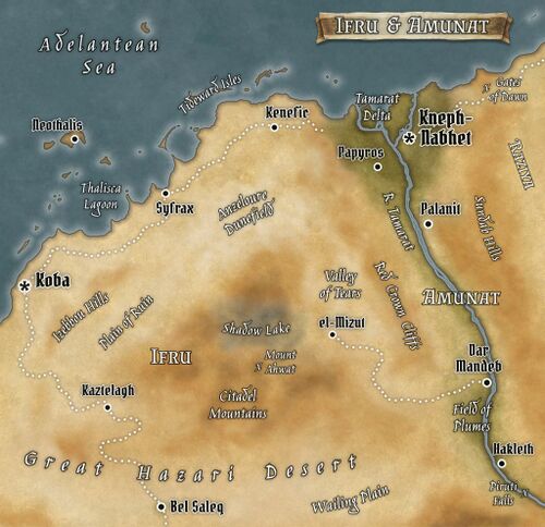
Amunat
| Allegiance | Sirdabi Caliphate |
| Capital | Kneph-Nebet |
| Demonym | Amunati |
| Official Language | Sirdabi |
| Official Religion | Azadi |
| Currency | fals/dirham/nour |
| Native Heritages | Amunati, Sirdabi |
Amunat is one of the Sirdabi Caliphate's north Idiri provinces, lying directly to the west of Raziya and east of Ifru. A dry and sunny land, the province is dominated by the great River Tamarat, whose seasonal flood waters and the rich silt deposited by them each year have made the surrounding valley among the most productive agricultural areas in the world. Amunat has a proud and extremely long history, having been for millennia one of the greatest kingdoms of the ancient world, with a sophisticated culture that influenced peoples around the Adelantean basin and beyond. It retains much of this cultural cachet even today, along with a faintly exotic reputation for mystery and magic.
Geography & Climate
Amunat is one of the smaller provinces of the Sirdabi Caliphate, consisting almost entirely of the narrow valley of the River Tamarat. To west and east the province is bounded by rugged and extremely arid terrain, but in the lands touched by the Tamarat's annual floodwaters it is a well-watered and bounteous landscape. The floods and the broad channel of the river are in fact essential to Amunat's prosperity, if not in fact its very existence, for there is scarcely any rain that falls in Amunat and what little there is pours down in short-lived tempests more destructive than beneficial. Fortunately the waters of the Tamarat rise faithfully every year, following the dry season that lasts from to Jirguz to Kholabi. Somewhat less fortunately, while the onset of the flood itself is very regular, the degree of flooding is less so, and it is not uncommon for neighborhoods or even whole villages to be inundated every few to several years if they are built too low and close to the riverbank.
For several miles in either direction from the river, the land is flat or gently rolling, and generally covered by fields of grain and shady groves of date palms. Where the land is not cultivated it is often watery marshland and dense papyrus swamp, which offer their own vital sources of food and material. The further one goes from the banks of the Tamarat, the drier the landscape steadily becomes, transitioning from cropland to pasture, and then swiftly to barren desert. The Sundab Hills in the east mark the much-disputed border between Amunat and the neighboring province of Raziya, and have historically been the site of conflict between these two age-old rivals. To the west the border with Ifru is a much friendlier one, marked by the eastern edge of the Citadel Mountains and the northern end of the Red Crown Cliffs . Although the Tamarat river valley ends below the cliffs, Amunat has since ancient times laid claim to the Valley of Tears which lies between them and the Citadel. Although overall quite desolate and isolated, a single productive well supports the town of el-Mizut in the middle of starkly towering escarpments and the barren flatland of the valley.
While Amunat is generally fairly flat except for its limited hinterlands, the terrain does rise gradually from the low marshy land of the Tamarat Delta in the north, to the Numizana Foothills and Piruti Falls in the south.
