Ifru
| Allegiance | Sirdabi Caliphate |
| Capital | Koba |
| Demonym | Ifari |
| Official Language | Sirdabi |
| Official Religion | Azadi |
| Currency | fals/dirham/nour |
| Native Heritages | Tessouare, Sirdabi, Razmani |
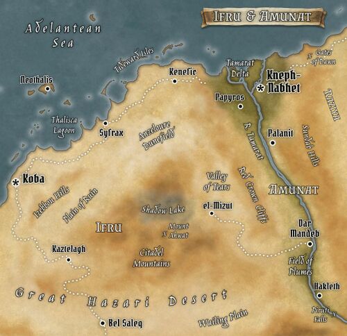
Often considered the backwater of the Sirdabi Caliphate, Ifru is nonetheless centrally located among the caliphate's Idiri provinces, lying along the Adelantean coast east of Tessere and west of Amunat. With a relatively small population, unforgiving terrain, and poor harborage, the province still plays a key role in trans-Hazari trade and its towns are vital waystations along one of the most well-traveled caravan routes of the continent. Ifru is part of the Tessouare heartland and was once a renowned center of civilization and commerce, from ancient times through the days of the Ruveran Empire. Numerous ruins lie scattered across the province, some of Ruvan origin, some dating back to the days of the great Tessouare kingdoms, all of them now desolate in the middle of half-forgotten valleys and fields of windblown dunes.
Geography & Climate
Ifru is a difficult land, with a hot and arid climate and punishing terrain that challenge both travelers and residents. The landscape holds a stark beauty for those who are untroubled by the vast empty spaces and isolation, but most people not native to the area -- and some of those who are -- fear the many areas that lie beyond the edge of the country's settlements. Most of the province's population is scattered along the Adelantean shore, which receives some welcome rain in the winter months that makes limited farming, grazing, and arboriculture possible. But scarcely a hundred miles inland from the coast these seasonal rains vanish, leaving the remainder of the province to the mercy of brief but violent storms that pound the land with torrential rain before vanishing as swiftly as they came on.
In long-ago times, in the days of the earliest Tessouare kingdoms and before, Ifru was a far more temperate and forgiving land. Tales and chronicles tell of verdant meadows spreading across the Plain of Ruin and filling the fields now covered in sand, thick forests blanketing the Citadel Mountains, and a vast and beautiful lake that nestled within the very heart of those wooded slopes. But of all this natural abundance nothing remains but dust, and the immense basin of bone-dry and darkened ground now called Shadow Lake.
While overall somewhat hazardous to traverse, Ifru is fortunate to lie at the northern end of one of the safer routes through the Great Hazari Desert -- if "safe" can be used to describe any route through that vast and perilous land. The town of Bel Saleq, situated at the southern edge of the province, owes its existence and its relative prosperity to the deep wells there whose sweet-tasting waters have never failed. Few who follow the caravan route through the town dare to deviate far from its path, and the Wailing Plain that stretches out just to the east is among the most desolate spots in all Idiri.
The foothills of the Citadel are much less menacing, though by no means easy to pass through. Some amount of forage graces the trail, a mix of sparse bunchgrass and twisted shrubs, and additional water is seasonally available from intermittent springs amidst the rocks. The village of Kaztelagh, with its own manmade citadel crowning the bluff, relies on these springs as well as a handful of natural rock tanks that fill with the torrential rains from thunderstorms. Far up in the mountain heights remnants of the once extensive forests still survive, but are generally left alone due to the reputation of the mountains as jinn-haunted.
People
Economy
The economy of Ifru is almost entirely dependent on its role as middleman for the trans-Hazari caravans that pass through the province, bringing a wide variety of goods to and from central and southern Idiri. The border town of Bel Saleq functions as a jumping-off point for caravans headed south across the desert, and plays an equally vital role in giving relief to the merchant trains that have just completed their harrowing trek northward. Though the capital of Koba is the official northern terminus of the trade route, most of the goods do not remain there long before being loaded onto ships and transported to much larger trade entrepots such as Kneph-Nebhet or, still more often, Omrazir in Raziya.
Serving more localized trade and travel, the Trail of Sand treks along the Adelantean coast, forming a useful overland link with neighboring Amunat.
